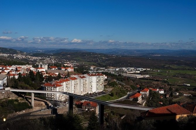
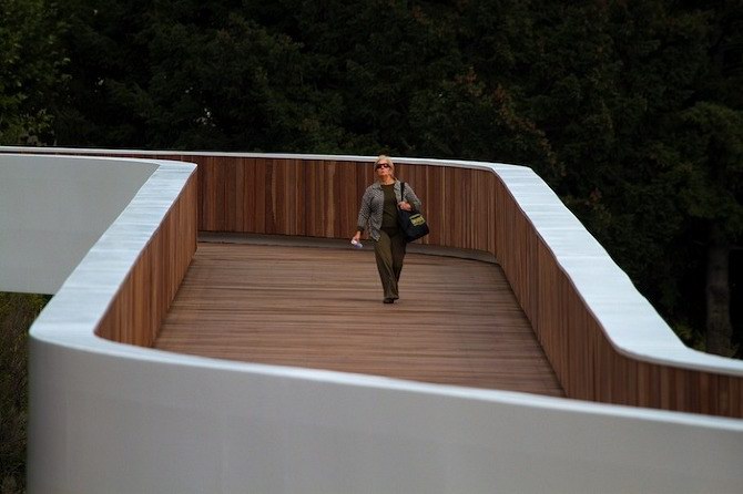
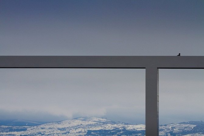
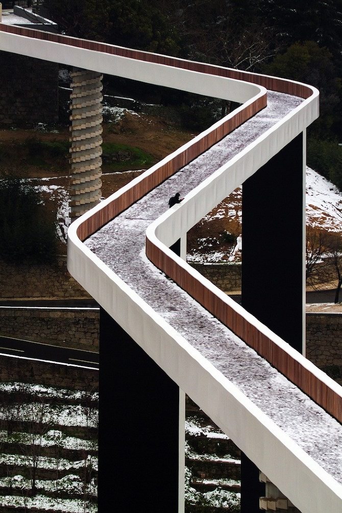
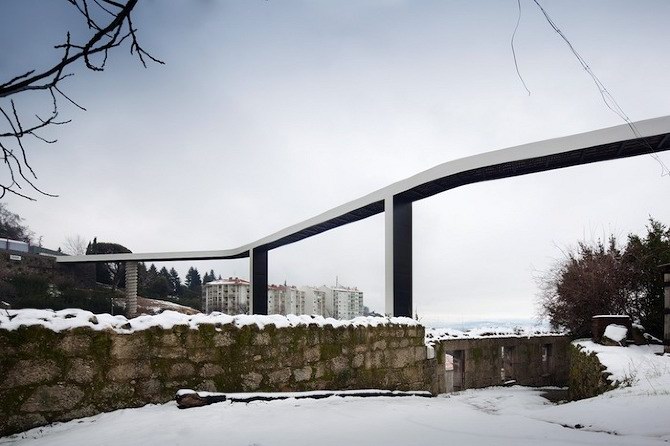
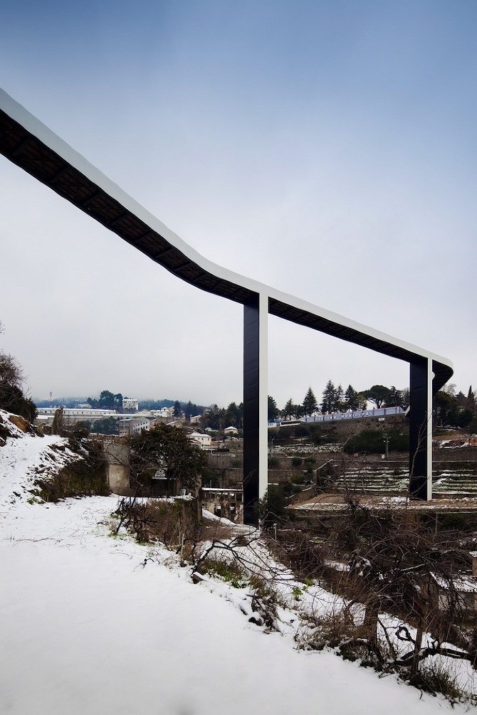
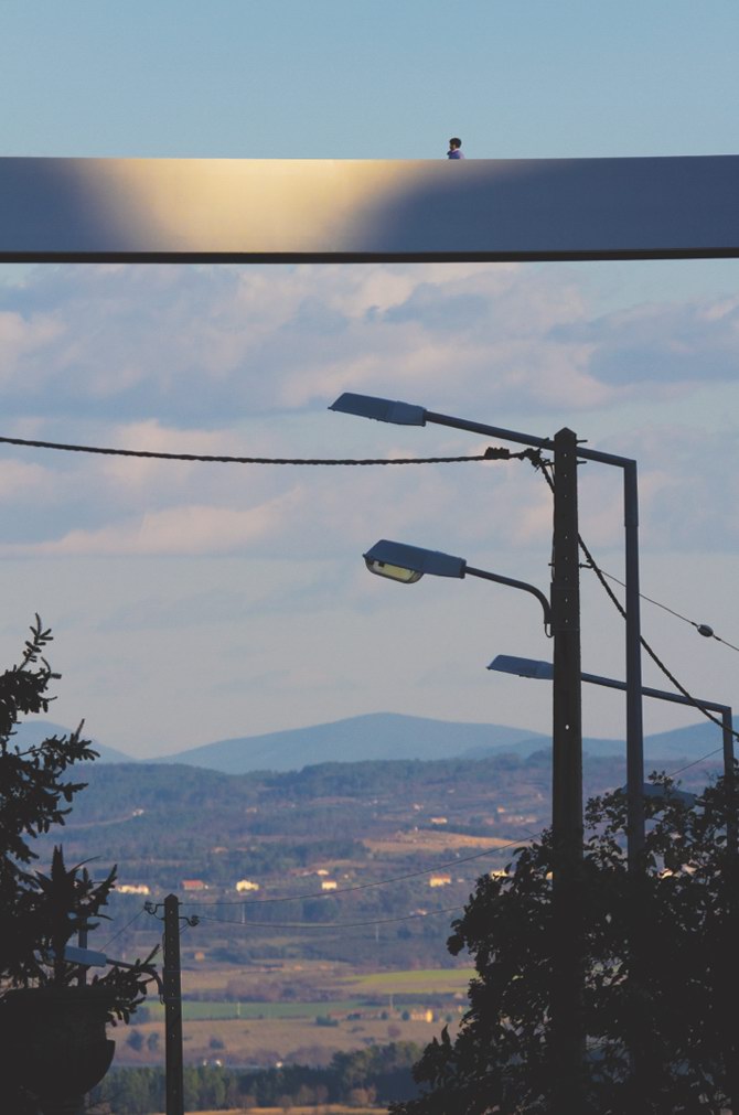
葡萄牙建筑设计公司Carrilho da Graa arquitectos在葡萄牙科维良的 ribeira da carpinteira 修建了一座步行者之桥(Pedestrian Bridge)。这座蜿蜒、分段的桥梁架设在山谷之上,绵延达220米。中心桥跨与线形山谷方向垂直。桥的另外两段则曲折导向于它们的参照点方向。两点之间的连接已经不再是它们间的最短距离了。几何学上的布置受到视觉定位与邻近的“serra da estrela山”绝对高度的影响,而在较低矮的一侧是广阔的cova da beira。
中间两个桥墩的宽度与桥身相同,给人一种纤细而精致的感觉,桥身内部采用了木质材料,让步行者走在上面很舒服。独自漫步桥上不禁袭来一种莫名的孤独感,感慨天之大而我之渺小,怅然间也走道桥之另一头……( )
英文资料:
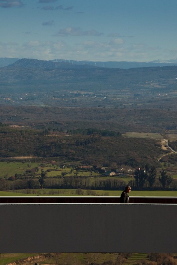
The core of the city of Covilh, in the interior of Portugal, occupies a promontory in the southern foothills of the Serra da Estrela, visually dominating a vast and fertile landscape of relative flatness ― the Cova da Beira region ― which extends from the Estrela to the Gardunha and Malcata mountain-ranges. The particular topography of the territory in which the city is inscribed not only determined the form and strategies of its urban design as has, up to a relatively recent past, provided the technical and economic means for its development. In fact, the watercourses of the valleys of Carpinteira and Goldra (or Degoldra), which respectively delimit the promontory of the city to its north and south, provided the driving force for the industrialization of the traditional wool processing activity, recognized since as early as the sixteenth century and fed by the grazing herds of sheep (and, marginally, goats) created in the mountain, but also by those who demanded their summer pastures. This transhumant phenomenon encompassed a territory that stretched from the highlands of the Douro, in the north, to the Alentejo, in the south, and east into Castile, corresponding the visual domain over the immediate landscape to a wider territorial area, significantly in result of the movement through that same land mass. Reflected in the city, this period of development led to its expansion not only towards the valleys, with the industrial occupation of the thalweg, but later also in the direction of the ridge north of the Carpinteira valley, opposite to the city, where during the decades of 30 and 40 of the twentieth century the Penedos Altos working class neighborhood was built to accommodate the manpower of the then so-called “factory town”. The city’s expansion beyond the valleys enhanced the perception of its topography, but the subsequent decline of the industry fueled by the water courses, with the consequent abandonment of its place and its infrastructure, returned, now with a paroxysmal effect, the valleys of Goldra and Carpinteira to the condition of orographic accidents around which the city had grown. Accidents that the city is now forced to bypass in its internal movements, and that only perceives as negative spaces, as “spaces between”.
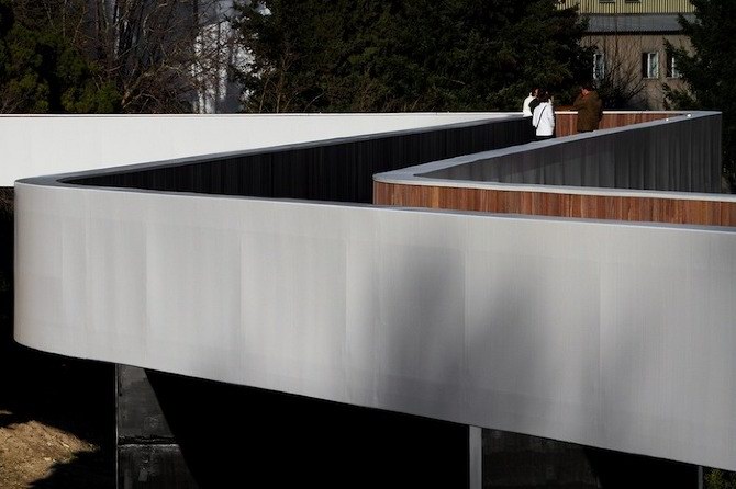
The design and construction (2003 – 2009) by Joo Luís Carrilho da Graa, with Afaconsult, of a cycling and pedestrian bridge over the Carpinteira valley as part of a plan to “flatten” the experience of movement through the city and between its center and the outlying areas, draw a line on this landscape that determines and provides a new possibility of movement across the valley. Above the steep granite slopes of the water course, where the hollow facades of the woolen mills and the granite walls that supported the Ramolas de Sol (structures for drying of the wool) remain, the bridge is drawn, curve and counter-curve, anchored at the level determined by the platform of the Penedos Altos municipal swimming pool on one side and, 220 meters farther, the same level in the opposite hillside, 52 meters above the watercourse. The non-perpendicularity between the imaginary line connecting the points of mooring and the axis of the valley provided the opportunity for the layout of the bridge deck to install, rather than a rupture, a slip of the Euclidean paradigm: in the presence of obstacles, the shortest distance between two points can be, according to Galileo (or at least according to the character Galileo in Brecht’s homonymous play), a curved line. A curved line in three sections, the middle section normal to the slopes and perpendicular to the axis of the valley and, inflecting at each end, the terminal sections directed towards the pre-determined landing points, drawing a serpentine, reminiscent of William Hogarth’s Line of Beauty (The Analysis of Beauty, Written with a view of fixing the fluctuating Ideas of Taste, 1753), a possible reference. Reference not insignificant because, in effect, Section XVI of A Philosophical Enquiry Into the Origins of Our Ideas of the Sublime and the Beautiful (1757) by Edmund Burke, on delicacy as an attribute of beauty, quoted above, seems to metaphorical and precisely describe how the bridge is materialized and supported: two parallel steel beams coated in the same material, with 1.75 meters in height delimit the 4.40 meters width of the deck, establishing its section, resting on four pillars, two of which coated in steel and with the same exterior dimensions of the deck, planted beside the bed of the stream, and the remaining two, circular, shorter due to their slope-side landing, in concrete partially covered with granite blocks, formal and physically disconnected from metal structure ― paradoxically both present and almost invisible in the reading of the span. An appearance of delicacy, of fragility even, which results essential to its beauty and singularity.
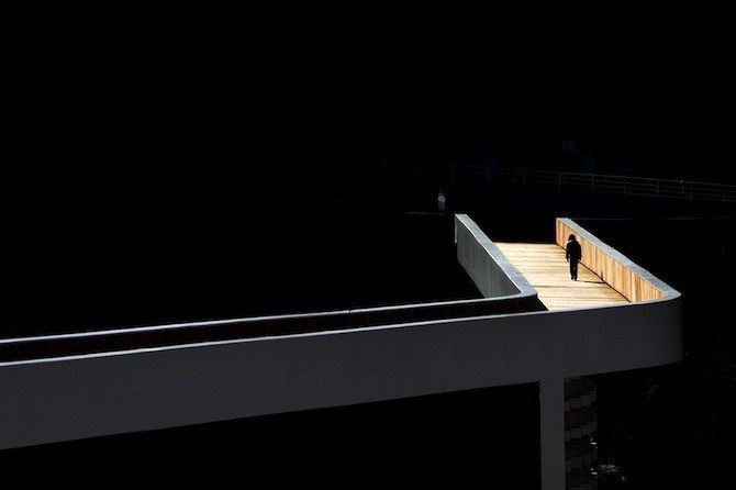
In its crossing, the outer metal armor, kind of protective exoskeleton, gives way to an interior ― pavement and guardrails ― of azobis-wood, gentle and tactile, providing an haptic experience simultaneous to the visual experience complexified by the development of the bridge that sequentially draws the eye to the mass of the mountain, the growing closeness of the opposite slope and the landscape of the plain opened at the end of the valley, landscape that is exposed to a perspective gaze hitherto impossible. At night, between the darkness of the mountain-range and the lights on the slopes and the on distant landscape, now without horizon, the guardrails emanate the light that guides the route on the deck, focusing the gaze on its interior.
Cladded in white, and black in the soffits, the Carpinteira bridge draws a portico, almost abstract, and at the distance almost physically indefinable ― sort of mirage or impossibility ― over the river and the landscape, installing a new framework of physical and visual relations, thus providing a re-mapping the territory. Re-mapping because it is in fact in the experience of motion, or rather, in the way that conveys the perception of the experience of motion in the landscape and the perception of the landscape itself, that the bridge discloses its recognition of the specificity of this territory. Because it encourages us not only to cross it, by necessity (or desire), where before we could not, but because it also encourages us to physically wander, after we have visually roved, the landscape that it reveals. Because it is able to make coexist, in itself and the landscape, two time-spaces: the Euclidean space, metric and hierarchical, defined by a mobility plan, measured in distances and travel times, eminently functional, and a space centered on the experience of the body as a recipient of haptic and visual stimuli, traveled intensely at a speed that is relative (simultaneously very fast or very slow, as a result of the experience desired by, or necessary to, the moving body), predominantly sensorial.
转载请注明出处。